
Become a part of your journey
You are here
Further Afield's Journal
The Travel Nook
Unique Hotels of Ireland - The Lake Hotel
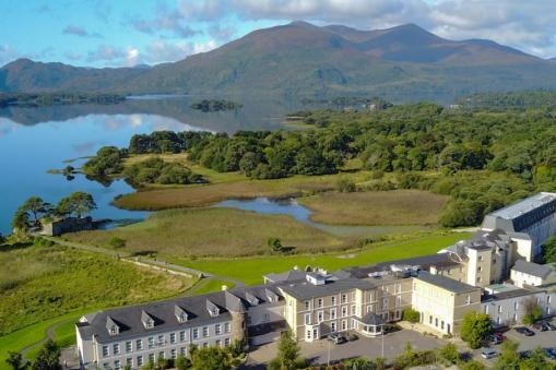
Owned by the Huggard family since 1940.
The Lake Hotel. Killarney, Co. Kerry.
The Lake hotel in Killarney was a purpose-built hotel back in 1820. Owned by the Huggard family since 1940. Not that this was the now renowned familiar name in the hotel and hospitality first adventure into the hotel business.
Martin Huggard, a farmer in Co. Kerry purchased the Bayview Hotel Waterville in 1912. His wife Mary had been working at the Great Southern Hotel. The Butler Arms in Waterville was added to the portfolio. Anyone visiting here will see references to Walt Disney, who spent time with his long-time friend Charlie Chaplin. He having set up home here for many years.
Through the years Mary’s experience in the hospitality sector was a treasure chest of information for people coming into the business and for the promotion of Irish Tourism. A number of other hotels were added to their list. Family sons and daughters became involved in the business.
The expansion of the Huggard chain of hotels continued. In Cong, Co. Mayo when Noel bought Ashford Castle, previously a home of the Guinness family. A restoration of enormous proportions was needed but none better to take on the onerous challenge. In the neighbouring Co. Galway Ballinahinch Castle was added. This was the home of Richard Martin, one of the famous tribes of Galway and founder of the Society of Prevention of Cruelty to Animals.
Huggards, have celebrated over 100 years in the hotel business. Being the pioneers of an industry that has recognized their achievements and dedication. If one looks at the timeline and the birth of tourism, through a war of independence, a civil war, two world wars, an economic depression, no subsidies or Government grants, credit has to be given and appreciated by those of us who can now reap the rewards for their efforts. Of a family that now sees the third and fourth generations keeping on the business.
The Huggards may have come from France originally and not all of then stayed in Ireland. There are as many as 80 families of Huggard in Canada, mainly in the Province of Ontario. Starting out as farmers but then other businesses, as well as politicians.
A hotel with 131 bedrooms, each having their own specialty. Dining or enjoying a drink with local musicians in the bar of an evening, as you gaze onto the lawn, with the beautiful Lough Leane, hugging the shore line. In the distant background, a silvery moon dances on a clear crystal carpet of water. Deer stroll by at almost arm’s length. Breakfast in the dining room, with a sun kissed mist, above the ripples of a trout stream. The majestic Macgillcuddy Reeks, (mountains) towering in their splendour of sandstone. A symbol of nature’s strength, with the tiny gouged out lakes, left behind as glaciers had sneaked by, millions of years ago.
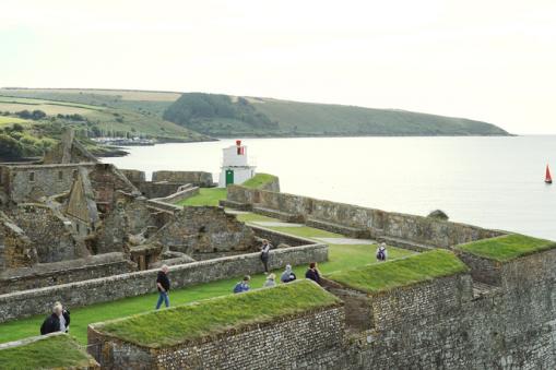
Take a trip to Ross castle. The home of ‘The O’Donoghue’. Lord of the lands of Kerry. It’s said by many that his ghost lives beneath the waters of Lough Leane and that every seven years on May 1st “La Bealtaine”, the great Celtic feast of Summer, he rises from the waters on his White horse and rides around the lake until the sun has risen to its zenith. Then the gravitational pull draws him back to join the fairies underwater and the other world. Anyone who happens to see him, will have good fortune for the rest of their lives. So be prepared.
The area around The Lake Hotel in Killarney has a plethora of choices for tourists, from water activities, golf, hill walking, mountain climbing, biking, day tours to Dingle or the Ring of Kerry. If you want to chill out and use the leisure facilities, there’s that too.
Exclusive Further Afield Travel and Tours
Maximum 22 people
Stories Written Into the Lands - May 9, 2022
www.furtherafieldtravel.ca/stories-written-land-ireland
Discovery Ireland - May 21, 2022
www.furtherafieldtravel.ca/discover-ireland
Best of Ireland Family - August 12, 2022
www.furtherafieldtravel.ca/best-ireland-family-journey
Signature Ireland - September 19, 2022
www.furtherafieldtravel.ca/ireland-signature
The March of O'Sulllivan Beare in 1602
The Battle of Kinsale in 1601 and the subsequent defeat of the Old Irish Order as it's referred to, makes little reference to other Cheiftains outside of O'Neill and O'Donnell.
Plantations had been going on since Queen Mary 1 became Monarch in England. Her father Henry V111 having brought in the Surrender and Regrant Law. Laois and Offaly were the first counties to have been Planted with settlers from England. Unsuccessful in its experiment. During Elizabeth 1, a more stringent effort was made, which began a continuous outbreak of wars for those effected by losing their lands, through the late 1500’s.
The Earls of Desmond in Kerry, Ormonde in Kilkenny and Tipperary, O’Rourkes of Breifne, MacGuires of Fermanagh, O’Mahons of Monaghan, MacWilliam Burke of Connacht, O’Sullivan of West Cork, to name but a few. These were the warring factions to fight against the Plantations in Munster and Connacht.
Ulster was next. An effort had been made in 1585, to have a privately funded Plantation here but it failed. In 1594 the Earls of the Ulster had reconciled their differences and raise an army. Such was the wealth that O’Neill of Tyrone had amassed, that he could arm and feed 8,000 men. O’Donnell of Donegal could muster almost as many. The war that broke out would last for nine years and still has repercussions to this day.
An army coming into the north of Ireland in force had a choice of south Armagh or Sligo. Anything else would mean mountainous terrain. Battles at the Blackwater, Yellow Ford and Clontibret, brought success to the Irish Chieftains. Help was on its way from Spain. The problem was the Spaniards landed in Kinsale. The main war was now been fought in the north. The armies of the north marched south to join the Spanish and engage the English armies at Kinsale.
A defeat for the Irish at The Battle of Kinsale, changed Irish History.
The war continued throughout the country over the next year.
O’Sullivan led his forces back to his stronghold in West Cork, where he was attacked by forces of the Crown. 300 women, children and aged persons were concealed on Dursey Island, but the position was attacked shortly afterwards.
Donal Cam O’Sullivan Beare, Prince of Beara, 1st Count of Berehaven and as head of the clan, had the Irish title of “The O’Sullivan Beare”, with 400 soldiers and over 600 men, women and children, left the Beare peninsula, heading north on a journey of 500 kilometres, in an attempt to meet up with O’Neill. The date was the 31st December 1602.
Fighting a rearguard action through Munster. Encountering English forces and Irish enemies. Raiding villages and farms along the way out of necessity for food. Not that O’Sullivan hadn’t the money to pay for these foods but simply because the countryside was so decimated that people didn’t want to sell what little they had. On through Connacht and finally on the 14th January 1603 arriving at Brian Og O’Rourke’s castle in west Breifne. 15 days of a forced march, with little to eat, in the depths of winter, of the 1000 people that left on this epic journey, 35 remained. Some had died in battles along the way, others from exposure and hunger but a sizeable number just had given up and took shelter or fled from the group.
O’Sullivan Beare’s journey to meet O’Neill was another disappointment. The Treaty of Mellifont was signed a short time later. O’Sullivan sought exile in Spain where he was welcomed by King Philip 111 and lived in relative peacefulness until 1618 when he was murdered as he left mass at Plaza de Santo Domingo in Madrid. The Dublin, Englishman, John Bathe, was responsible for his death, a spy on behalf of the English Crown.
O’Sullivan Beare’s reputation was such that many of his line were army personnel. About 165 years after this walk, a General John Sullivan of New Hampshire, believed to be a descendant of O’Sullivan Beare, served in the American Revolution.
Figures from the Nine Years War account for 100,000 lives being lost on the Irish side, including mercenaries that had joined the armies. War and famine, a scorched earth tactic of warfare had led to hunger and starvation. 30,000 English soldiers lost their lives, through battles and disease.
A horrendous figure when you think that the population was about 1 million. One in Ten.
Musicians out there will be familiar with the piece of music “The March of O’Sullivan Beare”. A rousing, uplifting, enchanting haunting tribute to a tragedy of life.
Hill walkers can follow the path of “The O’Sullivan Beare” in many parts of the countryside. Respect the hollow ground and spare a thorough for them who went before.
Bridges Across The River Liffey In Dublin

We use the bridges every day, getting from one side to the other, while keeping the feet dry
We use them every day, getting from one side to the other, while keeping the feet dry and not being marooned by the high tide when you want to get back. Bridges dripping with history and wit, read on.
1. Sean Houston Bridge
Coming into Dublin from the western side we cross this bridge named now after Sean Houston who was executed after the Easter Rising of 1916. Don’t be surprised to hear it called other names.
Formerly called Sarsfield bridge, honouring a 17th century war hero and the first earl of Lucan, Patrick Sarsfield.
Prior to this it was The King’s Bridge, after King George 1V’s visit to Ireland in 1821. Many Dubliners still refer to this bridge as Kings Bridge.
2. Rory O’More Bridge
The original wooden bridge was Barrack Bridge, because of its proximity to the Royal Barracks. Built in 1670 it was also called the Bloody Bridge after the ferrymen who lost their lives after attempting to destroy the structure. In 1859 it was renamed the Victoria and Albert Bridge.
Renamed the Rory O’More in 1930. Another revolutionary from way back, having been involved in the 1641 rebellion. We Irish have long memories you know. This bridge is of beautiful cast iron and links Ellis Street on the north side of the city to Watling Street on the south side taking you up to the Guinness brewery.
3. The Father Matthew Bridge
Theobald Matthew was an Irish Catholic priest and teetotalist reformer. Known as Father Matthew. With the problem of over indulgence in alcohol in Ireland during the 1800’s he started the Temperance movement. With its success in Ireland, it spread it to the UK and then to the USA and Canada. This movement was very much responsible for prohibition being introduced in the 1920’s in North America and Canada. The Father Matthew bridge is the site of one of the first bridged crossing of the river in 1014, the year of the famous “Battle of Clontarf” when the High King of Ireland Brian Boru defeated a Viking and Irish alliance. Interesting that this bridge is located close to a brewery and a distillery.
4. O’Donovan Rosa Bridge
Formerly called Ormond Bridge back in 1760 after the Butler family of Kilkenny, later named after the Irish revolutionary Jeremiah O’Donovan Rossa. An Irish Fenian, a member of the House of Parliament in London. He went to the United States in the late 1800’s and became involved in the Irish revolutionary movement there. He was a pioneer in physical force utilizing dynamite in attacking the British Empire. Dying in the USA in 1915 his remains were brought back to Ireland and buried in the Republican plot in Glasnevin cemetery, Dublin. Patrick Pearce, the leader of the 1916 Easter rebellion gives a moving oration at his graveside. In 1760 a pub, that was named Mrs. Archers tavern, plummeted into the murky waters below as well as part of the bridge. There was no loss of life, however numerous quantities of drinks sank, causing more distress than would a bereavement.
5. Grattan Bridge
Very seldom referred to as such, Gratton was a parliamentarian back in the late 1700’s. Known to Dubliners as Capel Street bridge or Essex Bridge. Essex being associated with Elizabeth 1. A statue of King George1 was a feature of the bridge way back, removed in 1753, it now resides in the Barber Institute of Fine Arts in Birmingham. The bridge joins Capel Street to Parliament Street with the 18th century portico and copper dome of City Hall. Off Parliament Street are a labyrinth of passageways, alleys and cobblestone walkways, now a tourist attraction day and night, the “Temple Bar District”.
In yesteryear when young ladies, dressed up in their finery, for a Ball or Banquet, being held at City Hall, were being driven across this bridge many were the targets of kidnapping. Young men who had little prospect of marring above their status sought fit to kidnap an heiress. Books have been written on this topic.
6. The Millennium Bridge
A recent addition for the pedestrian traffic. Opened a few days before the dawning of the third millennium. Built in Co. Carlow, a hundred kilometres from it’s would be resting place. It was quite an achievement to have it transported on a single truck and then slotted into place by a single crane. Irish people being a little cynical had a wager as to how much of the bridge would be out on the streets or if it would be in the river. What do you know? It fitted. The architect even designed a commemorative plaque that doubles up as a manhole cover. Nifty or what!
7. The Ha’penny Bridge
Dublin’s oldest pedestrian bridge got its name simply because the toll to cross it was a half penny with turnstiles at each either side. William Walsh had a ferry going across the river until the bridge was built, he got a lease for 100 years afterwards. Inheritance is a wonderful carrot for your offspring’s. Daddy was very well taken care of. It’s estimated that 30,000 pedestrians cross the bridge every day. The toll ended in 1919. It’s said that at the time of putting in the bridge the citizens of Dublin had a year to decide if they liked it. If not, it would be removed at no cost to the city of Dublin. The official name of the bridge was Wellington Bridge. Named after the Dublin born Duke, that defeated Napoleon at Waterloo, twice Prime Minister of Britain. After our Independence it’s fondly called “The Ha’pennyBridge”.
8. O’Connell Bridge
The centre of the city. Built in the late 1700” s, then known as Carlisle bridge. It’s a road bridge linking O’Connell Street to D’Olier Street. By far the busiest junction in the city. The area is a hive of activity, Street art, musicians and now and again students and others have a Liffey swim, causing a little commotion. The river is tidal so the depth of water has to be correct. For the millennium the city fathers placed a clock in the river at the bridge to count down the time to the ringing in of 2000. Did it work, No, and nobody knows what became of the said clock.In 2004, a pair of pranksters installed a plaque to a fictional Father Pat Noise, this remained unnoticed until 2006, it is still there today. No, it’s not a square, in fact it’s the only traffic bridge in Europe wider than it is long.
9. The Rosie Hackett Bridge
This bridge was added on in 2014 to facilitate the crossing of the river by the Luas tram line. Rosie Hackett was involved in the rebellion of 1916 and was also a trade union activist. Women were very much involved in the struggle for Irish freedom and welfare rights, after our independence women had equal voting rights as men from 1922.
10. The Matt Talbot Memorial Bridge
We have mentioned Father Matthew, now we are at the other end of the scale. Matt as he is fondly referred to in song and story in Dublin had what we call, a weakness when it came to the demon drink. He got work in a brewery at the tender age of twelve (12). At the age of sixteen (16) he was declared an alcoholic, at 28 he decided to abstain from drink and turned to God, attending mass each morning at 5am. He would sleep on a plank of wood, that is if he could sleep, wearing heavy chains and knotted ropes, daily. He became heavily involved in the Catholic Church, dying at the age of 69 he had remained sober for 41 years.
11. The Sean O’Casey Bridge
Another pedestrian bridge, this time in the newly developed area of Dublin dock lands. With the tram lines running to Dublin Port this bridge is the short cut for the offices that have sprung up along the quays (river side). This area was a barren wasteland for a number of years. Due to the advent of Roll-on Roll-off trucks in the busy port. Prior to this cargo was ferried in and manually lifted off ships. On the quayside, sheds and stores chartered for the needs of workers and freight. Live cattle were exported to Britain, storage had to be available for animals and feeding in the area. That ended and so the docks became derelict. In the words of the playwright Sean O’Casey, this is a “Tale of Two Cities” the wasteland has become a thriving metropolis of activity.
The bridge, sometimes called the “Quiver in the River”, due to the apparent bounce in its structure.
12. The Samuel Beckett Bridge
This is a transformation from the bridges we have seen. Designed by Calatrava, a Spanish architect. If you look closely it looks like a Harp, on its side. This is the Irish national symbol. This is a swing bridge, built in Holland, shipped over and sailed up the Liffey. Much to the annoyance of many an Irish manufacturer and worker didn’t it sit right on top of the swivel pivot that was erected and closed perfectly into place on the other side. When travelling along the river it’s a splendid spectacle regardless of the time of day or night. With the development on both sides of the river it’s a welcome link keeping heavy traffic out of the city centre.
Joe Fahy
Ancient Stone Walls
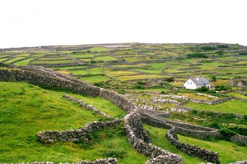
Natural beauty of the stone walls snake across the undulating landscapes.
Today we look at the natural beauty of the Island. The 'Emerald Isle' as Ireland is so often described as, is a painter's canvas. The green pasture lands, rolling hills and forests that have been captured on screen but leaves a lasting impression on the mind's eye.
One of the outstanding sights of the west of Ireland are the stone walls. The main variety of stone in Ireland is granite, limestone, sandstone, marble and basalt. In the west of the country granite is the most common stone, a relatively hard natural stone and is used in building these walls.
Driving along the roads tourists often remark of the gaps between the stones and on a clear day how the sky can be seen straight through them. Looking closely one can see that nature is having an effect on the stone. Lichens are growing here, this is a complex life form of two separate organisms, a fungus and an alga. Moisture causes the fungus, sunlight the alga and together we have lichen. Predominantly white but orange and yellow tinges can be seen. The walls provide protection to young calves or lambs in bad weather.
Most of these walls are ancient, built before farmers in this area had access to mortar or other cement like materials. These are known as "Dry stone walls", lose stones placed on top of one another with no mortar or other cement like materials. To build a dry-stone wall is somewhat like a jigsaw puzzle, first you have to have a variety of stone at hand. Having cleared the ground for the outline of the wall it's now ready to start building. Starting with a wide base each stone must properly rest within the wall, sitting still and balanced atop the last layer. Part of the technique is to place the smaller stones along the bottom and then finish or cap the wall of with larger and heavier rocks. This may seem strange, but the downward force of these larger rocks can help pack down the bottom layers, compressing them together and preventing them from moving or falling.
Why use stone? On the west and southwest the land is poor. If it's not peatland it's rock. For most farmers to make an income, they have to grow grass. So, get rid of the rocks results in the ability to grow more grass. The stone or rock can be used to build walls for separate fields or divisions for animal husbandry or crop rotation. On the eastern counties the soil and land are of a much higher quality with very little stone. Land divisions and fields are of ditches and hedges, suitable for drainage and farm management.
Famine Walls. In the 1800's, (1845-1852) Ireland was one of the worst countries in Europe to have suffered the worst from the failure of the potato crop. Various methods of relief and charities were enacted to prevent the starvation and death that occurred. The sight of these walls however beggars believe, a government department introduced a building program that would employ a workforce to build walls in the middle of nowhere, on the side of mountains and hills like the Burren in Co. Clare, Co. Kerry and Co. Galway. Walls dividing nothing from nothing. The renumeration for same was hardly worth the physical strain of the labour exerted. If you are hiking or hillwalking throughout the western part of Ireland you will see many examples of "The Famine Walls".
Enjoy a drive through the countryside on a fog-soaked evening watching the stone walls snake across the undulating landscapes as they disappear into the mist. What tales they can tell of a people that ploughed and tilled these fields. Of songs that were sung on an Autumn day as harvest came to an end. The shadows that mirror yesteryears of generations long since passed.
Ireland’s Hidden Gem

Dingle peninsula, the most westerly point of Europe, a remote corner of Ireland nestled on the edge of the Atlantic Ocean. A range of mountains maps its spine from Slieve Mish to Mount Brandon, the second highest peak on the island of Ireland.
Driving along the road from the town of Tralee, we see the lush green grass giving farmers a comfortable income. With the Gulf Stream bringing this temperate climate to the region, farmers are not burdened with the cost of having animals indoors for as long a period as in other parts of the country. Dairy cows a plenty to be seen, not to mention the thousands of sheep. Forestry has been a recent development. Peat bog land for harvesting turf to keep the home fires burning.
The town of Dingle is a major fishing port, a hive of activity along the harbour front with trawlers and boats landing their catch and trucks loading for destinations at home and in Europe. Jockeying for space are the cruise boats and sailing vessels taking visitors out on the bay.
Dingle, a Bohemian town has a pulse driven by an arty variety of dwellers, galleries, handcraft stores, interesting streets lined with pubs, cafes and shops. This is a town that depends on the tourism trade. A very welcoming atmosphere where the locals are sometimes as informative as any guide. The restaurants and pubs have an array of food choice. Relaxed in their dedication to excellence, they are there to help and please. If you want a full meal or a snack it's here. John Benny's pub is a great place to get food and/or drink during the day and they often have a great session (Irish music) at night.
Hikers, bikers, those that enjoy the walking trails, cyclist, golf, and horseback riding, all take delight in the region. Water activities, surfing, kayaking, swimming, or angling, there is lots of choice. Education holidays where you can learn the language. Dingle is one of the areas in the country where most locals are bilingual and the Gaelic language is cherished. The Gaelic games can also be experienced. Heritage, geology and religion, what more could you ask for?
Dingle is well known for the film location of movies like Star Wars episode VIII, The Last Jedi, Ryan's Daughter, Far and Away. Writers and musicians are also drawn to the area. The road west out of the town is the most scenic drive you will ever experience. Described by National Geographic as "The most beautiful place on earth".
As we leave the town we are into the countryside immediately. We cross the bridge that has us hugging the hedges. Looking at the variety of vegetation as we pass, Palm trees, Bamboo, Fuchsias, and Montbretia, certainly are not native to Ireland, they were introduced to these parts mainly by Lord Ventry, the Land owner of this region in years past.
We travel past a small national school with only two classrooms. This would be characteristic of rural Ireland. Looking out on the ocean you can see two rocky outcrops, "The Skelligs". Skellig Michael contains the remains of a sixth century monastic settlement, today a nesting and breeding ground for Gannets (seagull like bird). Across the bay we see Valentia Island. It was from here that the first transatlantic cable was laid to Canada's Newfoundland in 1866 and was in use until 1965.
We pass a Stone Age ring fort on the waters edge dating from 500 BC. Bee Hive shaped huts dot the landscape. These would have been the homes of Hermits in early Christian times.
In 1927 as Charles Lindbergh flew over this spot, imagine the thrill both for himself to see the land and for the people underneath to see this thing flying overhead. He was on his way to Paris.
Moving along the drive we come to Dun Chaoin, the most western point in Europe. Here you can see the Blasket Islands, a group of five islands now uninhabited since 1953, with a history all of its own, storytellers and writers, tragedy and love.
Driving through villages, with character and where characters abound. Ballyferriter, Baile is the Gaelic for town, Ferriter a family name from the Normans of the 12th century and giving the village its name, Anglicized to Ballyferriter.
Kilmalhedar church, a ruin dating back to the 13th century has some great examples of Ogham writing, as well as a Sundial stone.
Gallarus Oratory, a place of worship standing for over 1200 years, is a typical example of a corbeled structure. The walls having been raised to the required height are then progressively overlapped inwards to form the roof and finish with single slabs on the ridge to complete the building.
As we arrive back in Dingle we stop to explore this world's hidden gem of beauty and grandeur.
Suggested Tours
Stories Written Into the Land, May 9, 2022
Discover Ireland, May 21, 2022