
Become a part of your journey
You are here
Further Afield's Journal
The Travel Nook
KIWI CULTURE MEETS AUSSIE CHARM
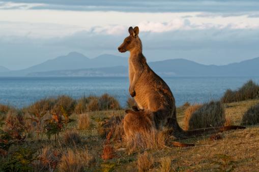
New Zealand is one of the youngest countries in terms of its human history. It was the last large and livable place in the world to be discovered. The Māori people that were first to populate these islands came from the Polynesian islands in the Pacific Ocean.
The Māori’s or Kiwi’s as they are known, are rich in history and a mainly oral culture, and the myths and legends of this indigenous race have been what the children of the upcoming generations hear as part of their education.
The Māori’s were seafaring people, passionate about sailing or canoeing. Back when Europeans thought they’d fall off the edge of the world, if they went too far, these people set off in their waka (canoe) exploring the ocean and seas. The ancient mariners had passed down their skills of reading the stars and judging distances and directions, Sirius is the most prominent star in the southern hemisphere, the ocean currents were what today’s highway would have been. Stories are told of sea creatures and phantom ships that guided sailors home; Seals that had taken on human form to marry a sailor that they fell in love with and then on stormy seas or winter gales when the sailors were in fear of losing their lives, their wives would return to the water to be with them, saving them or dying with them.
In sporting circles in New Zealand the world revolves around rugby, The All-Blacks are the National Rugby team. On the day of a game there is a wonderful array of colours, pomp and passion displayed by the visiting and home supporters, crowds are gathered at the venues long before the game and the atmosphere is palpable. The stadium is tense prior to the start. Instead of the National Anthem being played and sung the All-Blacks perform the Haka (a war dance). This is an old Māori custom that used to be performed going into battle. When facing a powerful united team, with them stamping their feet, shouting words of war and angry fists and arms depicting their intentions, the hope is that it would raise the hair on the heads of the opposing team. That alone might unsettle them and it could be worth a few points on the scoreboard.
Cruising the North island, you’ll see Auckland port, a harbour with an impressive amount of yachts and boats. See the whales and dolphins through a transparent sea of blue waters. Enjoy the cuisine along the seafronts. Tongariro and Napier are towns hugging the coast as you make your way into Wellington. The city of Wellington is the capital. Visit the parliament building, the museums, galleries and so much more. It’s also a busy seaport with fishing vessels, and ferry boats.
The South Island has a great selection for the tourists. The simple port of Picton is where the ferry service boats dock when arriving from the north island. Places to visit: Christchurch, Queenstown, Milford Sound, Mt. Cook National Park, Franz Josef Glacier, Dunedin on the very south of the South Island has its Penguin colonies and the Royal Albatross plus Emerson’s Brewery tour.
One of the renowned citizens of New Zealand is the late Sir Edmund Hillary. Born in Auckland in 1919, he had a keen interest in mountaineering from an early age. He achieved notoriety by becoming the first man to climb Mount Everest, in 1953, with one of the Sherpa support team, Tenzing Norgay, a Nepalese-Indian mountaineer. Hillary was knighted that same year by Queen Elizabeth II. Edmund reached the Antarctic and the South Pole in 1958. This is truly a remarkable story, Hillary and his crew were part of a large group of a Commonwealth Trans-Antarctic Expedition (TAE). Accompanying the expedition were scientists, mathematicians, engineers, and geologists. Hillary and his four man team set out for the Pole on three modified Massey Ferguson tractors, using half and full wheel tracks to drive through the snow and crevasses. As well as the tractors they had four sets of dog teams. The mission of this team was to leave food, fuel and other provisions at depots along the way. The team were making steady progress even though Hillary was not to go too far ahead of the main party. As they got closer to their end goal he ignored orders and continued to the South Pole. Read Hillary’s book ‘Nothing venture, nothing win’. With Neil Armstrong, the first man to set foot on the moon, in 1969. Sir Edmund Hillary flew to the North Pole in 1985, becoming the first man ever to complete the three Pole Challenge, the North Pole, the South Pole and the Summit of Mount Everest. It’s a challenge in modern times for many people to achieve.
New Zealand and Australia are still part of the British Commonwealth. Their armies were called upon during WWI, their troops landed on the shores of Gallipoli in Turkey in June 1915, their steadfastness, courage, bravery and humanity are considered outstanding in the annals of the 1914-18 war.
The island of Tasmania lies about 250 kilometres south of Australia. It was discovered by Abel Tasman in 1642, he named the island Van Diemen’s Land, after the Dutch governor who had sponsored the expedition. In 1769 Captain Cook of Great Britain mapped and claimed the island for His Majesty King George III. He renamed it Tasmania. The island was set up as a penal colony in the late 1700s. Convicted prisoners were deported from Britain and Ireland with guardsmen to hold them in a stockade. Female prisoners were also shipped to Tasmania. This was an exercise in populating the island. The island is ruled by Australia.
Settlements started to be developed. Hobart is the capital and largest town. Since about 1810 agricultural development projects were promoted, religious communities grew, a school was opened, a flower mill, a brewery, a post office and horse racing tracks. The population is just in excess of 500,000 people and the size is 85,000 sq. kilometres. There are about 2.5 million sheep that contributes to Tasmanian exports.
Captain William Bligh, he of ‘Mutiny on the Bounty’ fame, arrived on the island in 1809 after being removed as governor of New South Wales in Australia, his hope was of getting the governorship there. He didn’t, he had overstayed his welcome in Australia.
The Talbot family, whose roots go back to the French Norman invasion of England, which occurred in 1066, arrived in Ireland in 1171. They were granted a sizeably estate of land outside of Dublin in Malahide. A castle that was the family home of the Talbot’s still stands there today. It’s owned and operated by the Irish Tourist Board and is open to the public as a tourist attraction. The Talbot family survived on the estate until 1973 when the last member the Honourable Milo George Talbot died without an heir. However, back in 1821 William Talbot of Malahide, Ireland was granted 3,000 acres of land in Tasmania by the British government where he developed a sheep station and extended the farm to 8,500 acres. He named the estate Malahide, Rose Talbot inherited the property. She had never married. Her cousin, one Richard Talbot inherited the property in Tasmania after her death in 2009. To this day, the estate is still owned by a member of the Talbot family.
Onto Australia for the 3rd part of the cruise. Australia and Tasmania are members of the British commonwealth. Dutch explorers had arrived in Australia as early as the 1600 and they named the landmass New Holland.
Captain James Cook led the British expedition in 1770 and was first to map the eastern coastline of Australia and claim the continent as part of the British Empire. Looking at maps of the seas around the continent we recognize from their names of all the explorers who have been there, the Torres Strait, Bass, Cook, Cape York, New Caledonia and so on.
Botany Bay in Australia, where James Cook first landed, was set up as a penal colony and a naval base for the British fleet. Botany Bay was later renamed Sydney. Not all the ships carried convicts. There were free men and women, retired army and sailor personnel as well as adventurous tradespeople. William and Mary Bryant, two convicts who were on one of the ships of the first fleet, the ‘Charlotte’, had met on board and married shortly after arriving in Sydney. The journey from England to Sydney usually took over eight months. After WWII the Australian government needed to expand the population of the country, the £10.00 fare, which was the Assisted Passage Migration Scheme that was introduced to attract immigrants from Britain. This scheme lasted until the mid 1970s. During the period that the £10.00 fare lasted it’s estimated that 1.5 million British people would have travelled to Australia, a number of these were from Commonwealth countries.
The coastal cities and destinations that you can visit on a cruise would include Melbourne, Sydney, Darwin and Brisbane, national parks and the Great Barrier Reef, that’s now a UNESCO heritage site.
With a total number of 75 million sheep the export of meat and wool is of enormous importance to the country. Border control at airports and seaports are extremely thorough.
The population of Australia is 26 million people, it’s small in comparison to its size. The main employment is in, oil and gas exploration, mining of different minerals, finance, timber products i.e wood-pulp and lumber, chemicals, imports and exports, education and taxation.
St. Patricks Day
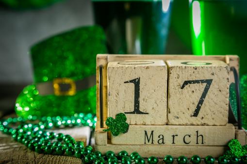
The 17th March is the feast day of St. Patrick, the Patron saint of Ireland. It’s celebrated all over the world wherever an Irish person has ever set foot. Some would have had no choice in the destination they ended up in. In the 1600 and 1700s deportation out of Ireland during the white slave trade had males and females sent to Barbados, Montserrat (known as the ‘Emerald Isle of the Caribbean’), Jamaica, the British West Indies, and the Leeward Islands.
Australia was another penal colony during the early 1800s. Some of those felons were indentured slaves, these were immigrants that bartered their trip with a guarantee to work for a certain length of time. Others were criminals who had to spend years of hard labour working there.
Once upon a time it was a disgrace to be considered a relation of a deportee that had ended up in Australia, nowadays there are those that consider it as a badge of honour. Songs of the ‘Wild Colonial Boy’ and films about ‘Ned Kelly’ are sung to rapturous applause. Watch the all-day celebrations, ‘Down Under, Matey’.
The largest parade is in Dublin City with a four-day festival for the occasion. Parades in every city, town, and village, marching bands, from all over Europe, North America and Canada, sporting events such as rugby, football, hurling, horse racing, and athletics.
Saint Patrick arrived in Ireland in 432, introducing Christianity to a pagan race of people. Patrick had come from what is now Wales in the United Kingdom. The Roman Empire had spread to England and Wales in the first century. With the Romans came learning, we know that Patrick had a certain ability to read and write, so he started to preach Christianity. Very shortly he had a number of followers. Through his teachings and the establishment of a church in Saul, Co. Down, Ireland was to become recognized as the birthplace of Christianity in western Europe.
For Saint Patrick’s day join in the celebrations, wherever you may be, with music, songs, dancing, storytelling and parades. Let the woes of the world, the financial strains or worries of living, the turmoil and uncertainty of tomorrow be eliminated from our minds for this day. Happy Saint Patrick’s Day to you all.
Planes, Boats and Trains
Let me introduce you to a trip of intrigue, enjoyment, colour and sheer beauty. You won’t regret it or forget it. Come fly with me, come fly, let’s fly away, in the words of ‘Frank Sinatra. On the opening day of your vacation you’ll arrive in Helsinki, Finland, the most northern capital city in Europe. Staying at a hotel in the city centre.
The following day experience a guided coach tour of the city with its outstanding architecture and attractions. It has been described as the most beautiful of small capitals worldwide with the relaxed atmosphere, the Bohemian nightlife, an array of second hand shops and the friendly characters you meet.
A train journey takes us to Rovaniemi in Lapland, the home of Santa Claus, on the way you’ll see the hundreds of reindeer in the farms. After seeing the old guy with his white beard you get your photo taken in the workshop.
With all of this snow we wonder how people get around, the answer is simple when you visit the husky safari and enjoy a sleigh ride. These dogs are amazing, their strength, determination and discipline leaves one with the utmost admiration for them and their handlers. Meet the local Sami people of Lapland and spend some time listening to their stories of Northern Europe.
Crossing the border into Norway and arriving in Kirkenes, a coastal town on the Barents Sea, one of the most important ports for harvesting king crabs. The town is 400 kilometres north of the Arctic Circle and it’s reputed for being the best place to view the Aurora Borealis. The Snow Hotel is home for the night.
The train and coach transport has ended for now. The cruise begins in the Arctic Circle, sailing along the northern coast and stopping at the port of Vardo, other fishing ports are Batsfjord and Berlevag. A trip on a snowmobile under the northern lights, stopping at Honningsvag the most northern town in mainland Europe at 71 degrees north latitude. Breathtaking. Rounding the coast the cruise liner heads south. Looking at the fjords and glaciers, the mountains and waterfalls, one thinks of the Vikings and their long boats that left these shores to travel to God knows where. Remembering Roald Amundsen the first man to set foot on the South Pole with his team of four others in 1911.
Crossing the Arctic Circle, the density of population is increasing, towns are bigger, the economy has improved due mainly to the North Sea Oil and Gas fields. Over 60% of Norway’s landmass is afforestation, 90% of housing is timber framed. Arriving in the town of Kristiansten visit ‘The Wooden City’, history museum, it’s also known as ‘The Dried Cod Capital’ of the world, with almost 100% going for export. The fishing boats and processing facilities are so impressive.
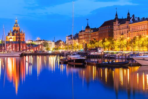
Cruising into the city of Bergen at the end of this section of the trip we disembark with our luggage. There’s a coach tour of the city and then to the hotel.
Morning call for breakfast and another day’s travelling. Boarding a coach to the village of Flam, transported 3,000 feet up to the train station, we pass a small hydroelectric power plant that runs the train to Norway’s capital Oslo. This is described as the world’s most scenic rail journey.
The final day of your vacation is spent in Oslo, touring the city by coach, and enjoying some free time to browse. Join the friends you have made throughout the journey for a farewell dinner at a local restaurant, sharing memories and laughter. Of course exchanging emails, addresses and phone numbers.
We bid a fond farewell to Finland and Norway. To a trip that one will never forget.
Contact Further Afield Travel and Tours for details.
The International Date Line, Prime Meridian and Time Zones
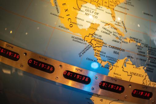
In the 1800s world trade and shipping was at such a pinnacle that timings needed to be agreed upon. The British Royal Observatory in Greenwich, London was accepted as the Prime Meridian or 0 degrees Longitude. The British navy, merchant ships, expeditions and exploration had the navigational skills to enforce their beliefs and power.
On the Transit Circle, the Observatory shows, that the earth is a sphere of 360 degrees. Going west from Greenwich and travelling to the halfway point of 180 degrees, you arrive at the International Date Line, another imaginary line dividing the East and West hemispheres, in the middle of the Pacific Ocean. This is the demarcation zone separating two calendar dates, if continuing east you substrate a day while going west you add on a day. This is not by any means a straight line, due to some of the island countries that’s on this line, to prevent a time zone, this line is curved around them, taking up its trajectory having cleared the island. The huge landmass between Asia and North America in the Bering Strait, Cape Dezhnev, Russia is always a day ahead of Cape Prince of Wales, in Alaska, even though there’s only 80 kilometres between them.
Greenwich Mean Time, is standard time worldwide, in 1992 UTC started to be used, Coordinated Universal Time. In 1876 was the first time zones came into being, Sir Sanford Fleming was a Scottish engineer who helped design the Canadian railway system, his desire was to make the railroad more efficient and avoid complications that would be inevitable resulting from different train stations that were setting the time schedules according to their local astronomical conditions. He proposed a system, a circle of 360 degrees should be divided into 24 time zones. Dividing 360 degrees by 24 hours gives 15, so every 15 degrees one travels that gives you an hour difference, plus or minus depending if one goes east or west. To begin with all clocks would be set at midday depending on the readings of the Sun. The system was adapted and now we have 24-time-zones. Yes there are countries that do not use daytime saving but internationally that’s allowed for.
Sundials, water clocks, and sticks stuck in the ground to measure the shadows of the Sun indicating the length or shortness of the days. In hindsight this worked perfectly well for the areas people lived in. Travelling long distances was not usual and so it wasn’t noticed. Sailors and merchants going overseas realized a drop in temperatures, or the decline in growth and changes in the seasons were different to what they had left at home. Scientists, astronomers, religious scholars, architects, artists and others were becoming aware of a broader universe. Expanding into a different world, times were changing and so were the needs for a more modern understanding of the world.
Saint Valentine’s Day 14th February.
If Paris and Milan consider themselves the cities of love, where will that leave Dublin, the capital city of Ireland? In 1836 Father Spratt arrived back in Dublin with the remains of St Valentine. Since that day the remains have been on show for all to see in Whitefriars Street Church in Dublin’s city centre. The Shrine contains an alarmed casket enclosing a number of St. Valentine’s bones and a vial of his blood.
The story of St. Valentine is pretty gruesome. In 270 AD he was working as a priest in Rome. The Emperor Claudius II was in power, remembered as ‘Claudius the Cruel’. Roman men were not joining the army when they were married, they cherished the attachment of their wives and families. Claudius II banned all marriages and engagements to get rid of this problem. Valentine realized this injustice and defied Claudius II by continuing to perform marriages in secret for young lovers.
On the 14th February around 270 AD, on the instructions of Claudius II, Valentine was confronted by a group of men who attacked him with clubs and then beheaded him. His martyred remains were buried in Rome. The Catholic Church canonized him in 1537.
Enter the Irishman Fr John Spratt in the early 1800s. A powerful preacher in Rome whose reputation had reached Pope Gregory XVI. After one of his sermons at a church in Rome where the Pope was present to hear Fr Spratt speak, the Pope was so impressed that he gifted him with St. Valentine’s remains. The priest carried the remains back with him to Dublin in 1836, where he in turn gifted them to Whitefriars church. Included was a letter from Pope Gregory XVI proving their authenticity. The remains had a Shrine and a statue erected in the church in the 1950s. The Catholic Church had an enormous following at that time and as word spread of this Shrine, people venerated it from all over Ireland, especially on the Saint’s patron day, the 14th February. As the tourism business became popular in Ireland, thousands of young and indeed, not so young people began to gather on his feast day in Whitefriars Street Church in memory of the Saint of Love. On a walking tour of Dublin this church is sometimes included.